
Coastrider
Duration of the project
Source of funding
Turku University of Applied Sciences
Total funding
51 817 €
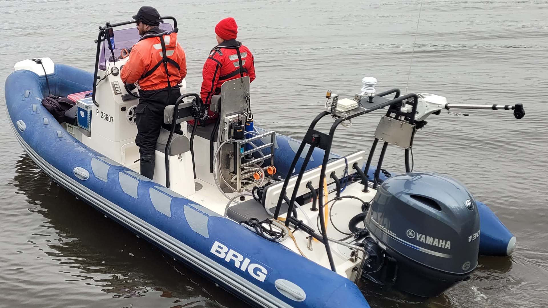
The Coastrider model aims to produce accurate and comprehensive measurement data from coastal waters and to create new statistical interpretation methods from this data. Measurements are conducted using a mobile and continuous measurement platform. Modern technology allows for the management of the environment based on reliable information. Coastrider supports broader research projects and practical environmental management work.
Understanding coastal carbon and nutrient cycles is globally of critical importance – especially in terms of mitigating eutrophication, climate change and biodiversity loss. However, there are significant shortcomings and qualitative gaps in current knowledge. Data on hydrography as well as on the distribution of carbon and nutrients in coastal waters with complex topography and hydrodynamics do not represent the spatial and temporal variation inherent in these environments. Moreover, estimates of the amount and quality of external loading from land to the sea are rough, apart from the largest river channels, even though a significant part of the runoff into coastal waters comes from outside them. The goal of the Coastrider concept is to respond to these gaps of knowledge by producing unprecedentedly representative empirical measurement data and creating novel statistical interpretations based on them. Strategically, the main aims of the concept are to conduct high-quality and up-to-date basic research and to implement its key outputs in a form suitable for concrete environmental management.
Modern sensor technology and statistical modelling have made it possible to produce comprehensive measurement data on the environment and its status without compromising spatial and temporal resolution. The environment can thus be managed increasingly more relying on evidence-based data describing real environmental variation than on general estimates and predictive models. The freely scalable and replicable Coastrider measurement platform produces spatially accurate, comprehensive and reliable observation data on a wide range of biogeochemical variables at time intervals determined according to the intended applications. The continuous underway survey platform consists of three parallel and interconnected automatic measurement systems, a weather station registering particularly wind, temperature and lighting conditions, as well as flow-through and vertical profiling systems, which are used to measure both horizontal and vertical variation, currently focusing mainly on water quality and greenhouse gases. All systems are built to be modular and easily customizable in terms of their sensor assemblage. Automatic measurement data are validated, calibrated and supplemented with information obtained in laboratory analyses of discrete water samples.
As a concept, Coastrider is an adaptable data collection, archiving and analysis system that serves as a logistics and information platform for a wide range of research topics and activities. In addition to empirical measurements, the concept relies on the application and development of hydrological models based on existing spatial datasets on the key hydrological characteristics of catchment areas. On top of basic research related to carbon and nutrient cycles and biodiversity, the obtained data are transformed into easily interpretable products (such as maps of loading hot spots and context-specific baselines for determining the loading status of different types of coastal environments) and utilized in concrete environmental management. In this context, the main aim is to be able to target water management solutions more reliably and cost-effectively – synergistically benefiting the coastal waters, the climate and sustainable land use, and thus reconciling economic and environmental values.
In order to further promote the goals of the Coastrider concept, we aim to apply and improve the concept over an increasingly long period of time, extending range of environments and covering a growing set of environmental parameters. As for environmental management, the concept will continue to be used as a joint targeting and impact monitoring tool for an increasing number of parties implementing concrete management measures, such as the municipalities around the Archipelago Sea. Thus, an increasing share of the economic resources allocated to environmental management can be directed to concrete actions investments in the actual concrete measures will within a scientifically robust framework, investments in individual projects, while the targeting and impact evaluation of those actions will be made in scientifically robust, ubiquitously harmonized and thus a cost-efficient way.
Contact us
Meet the research team
-
Research teams
Water and Environmental Protection
See all our projects
We carry out nearly 200 RDI projects annually together with working life and our international partner networks.