
SARUMAN: Archipelago Sea dredging roadmap – An analysis-based advice tool for maritime spatial planning
Duration of the project
Source of funding
Regional Council of Southwest Finland, Support for sustainable growth and vitality of regions (AKKE) – appropriation
Total funding
99 831 €
There is significant socioeconomic pressure for dredging in the Archipelago Sea. On the other hand, dredging adversely affects the water environment both locally and regionally. However, environmental permit and monitoring authorities lack a harmonized and objective knowledge base to weigh the benefits and disadvantages of dredging in an objective and transparent manner. The project’s aim is to produce the key elements of such an open knowledge base and openly demonstrate how empirically measured environmental characteristics are to be considered in practical decision-making.
Improving the water quality of the Archipelago Sea, which suffers from poor ecological status, is important for the region’s natural values and ecosystem services. The mosaic-like diversity of aquatic habitats and environments in the Archipelago Sea stems from its geographical features, such as post-glacial land uplift, wide zones of shallow waters and small-scale variation in topography. However, these same features create pressure for local dredgings, as living and non-living organic matter is being accumulated in waterways constantly getting shallower. These natural processes are heavily intensified by eutrophication, caused by organic and nutrient loading due to anthropogenic land use. Although the purpose of dredging is to promote important connections for traffic and tourism in the archipelago, dredging destroys habitats and releases nutrients, pollutants, suspended solids and organic matter from the seabed into the water.
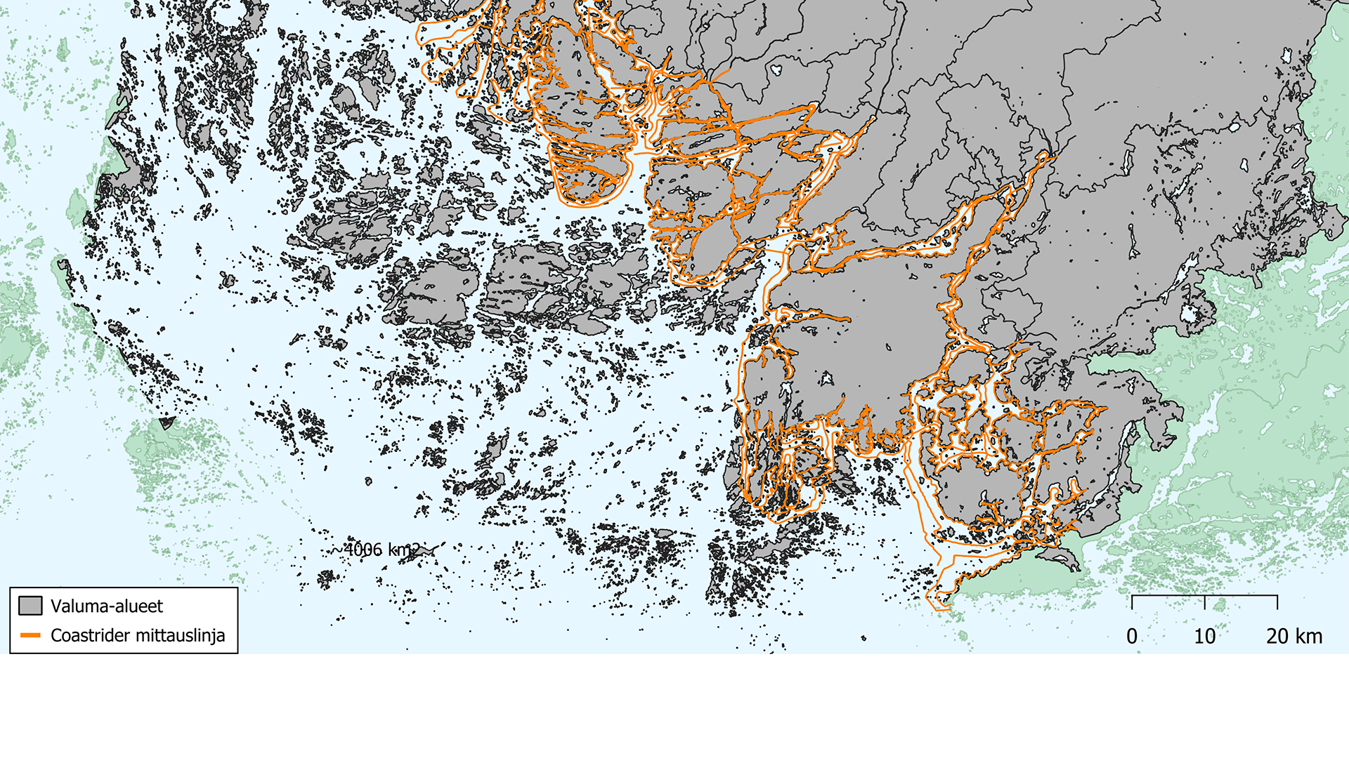
Satellite images reveal signs of approximately 15,000 small-scale dredging operations carried out in the inner and intermediate archipelago during recent years. The subsequent damage to biodiversity has only been assessed locally, i.e. within the dredged area, while the conclusions rely heavily on modeling rather than on empirical information. Meanwhile, there are no comprehensive studies on how dredging affects water quality, although such changes can influence the structure and function of the aquatic environment broadly and persistently. The intensity and extent of the water quality impacts are known to depend, in addition to the quantity and quality of dredged material, particularly on the hydrography and loading status of the environment. In practice, water exchange, mixing, and currents, as well as the concentrations of suspended solids, carbon, and nutrients in the environment determine together where, when, and how the number and extent of dredging operations affect the status of the aquatic ecosystem. These environmental variables also dictate the long-term benefits of dredging.
The SARUMAN project is founded upon producing accurate and detailed measurement data on the hydrography and pollution levels of the waters, covering the entire Archipelago Sea all the way to its outermost zone. Additionally, we will compile data from aerial photographs as well as dredging notifications and applications on the location, extent and timing of dredgings carried out in this target area. The immediate goal of the project is to refine the data collected from repeated water quality measurements and other sources into a form directly applicable to practical water management work.
The concrete outputs of the project are:
- classification of coastal waters into hydrographically distinct environments,
- characterization of the key hydrographic features in each environmental type,
- determination of the level of loading in each environment in relation to its hydrographic characteristics, and
- description of water exchange and mixing patterns among the different environments. As a synthesis of the produced information, we will present
- an environment-specific recommendation on the acceptable number and magnitude of dredging operations.
The assessment is thus based on weighing environmental sensitivity, carrying capacity and dredging history against the assumed permanence of the prospective benefits of dredging. The results will be conveyed as geospatial data directly to the authorities handling dredging notifications and applications, and as part of the continuously updated Small-Scale Dredging Guide to be published in the ELY Center’s Guide series in winter.
Additionally, the outcomes of the project will be used to investigate the individual and combined impacts of dredging. During the project, we will determine how the values of key status indicators, such as relative nutrient concentrations, correlate with the number and magnitude of dredging operations in both space and time. After the project, the water quality surveys in the Archipelago Sea will continue with other funding. Investigating the impacts, i.e., cause-and-effect relationships, requires a longer observation period, for which the SARUMAN project and the water quality surveys conducted in the Archipelago Sea in 2024 prior to the project provide a robust basis. the pre-project water quality surveys carried out in the Saar Sea in 2024 will provide a key basis.
Contact us
Meet the research team
-
Research teams
Water and Environmental Protection
See all our projects
We carry out nearly 200 RDI projects annually together with working life and our international partner networks.